School nearby Public School № 48
Georgia
School nearby Public School № 48
Public School № 48
Tbilisi, Gruzja
contacts phone
:
+995
Latitude:
41.7775592
, Longitude:
44.8123083
larger map & directions
read more
nearest School
125 m
კერძო სკოლა თამარიონი № 148
Tbilisi
School
read more
131 m
,,თამარიონი'' სკოლა-ლიცეუმი
Tbilisi
School
read more
460 m
Public School № 33
Tbilisi
School
read more
603 m
142th Secondary School
Tbilisi
School
read more
606 m
142
Tbilisi
School
read more
607 m
Public School № 142
Tbilisi
School
read more
617 m
Public School № 149
Tbilisi
School
read more
619 m
ა(ა)იპ #31 საბავშვო ბაგა-ბაღი
#, 40 Chargali Street, Tbilisi
School
read more
699 m
სკოლა-ლიცეუმი ფესვები
Tbilisi
School
read more
703 m
138 public school
Tbilisi
School
read more
740 m
Temqis Dasaxleba
Tbilisi
School
read more
812 m
სსიპ #143 საჯარო სკოლა
#5 ურეკის ქუჩა, Tbilisi
School
read more
814 m
143 სკოლა
9 შატილის ქუჩა, Tbilisi
School
read more
818 m
159th Secondary School
Tbilisi
School
read more
819 m
159th secondary school
Temqa, III M/R, V Block, Tbilisi
School
read more
823 m
#113 ბაღი
4 Ureki Street, Tbilisi
School
read more
1.088 km
saswavlo centri
Tbilisi
School
read more
1.545 km
კერძო სკოლა შპს დავითიანნი
Tbilisi
School
read more
1.636 km
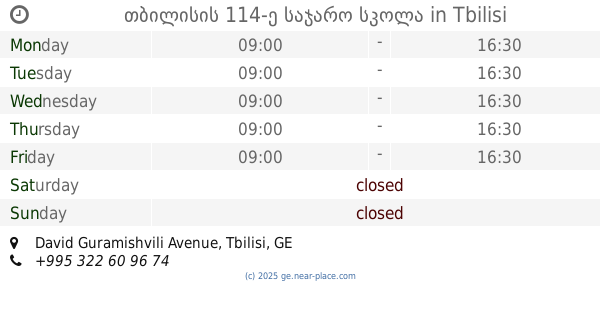
თბილისის 114-ე საჯარო სკოლა
David Guramishvili Avenue, Tbilisi
School
read more
1.783 km
15th secondary school
Tbilisi
School
read more
1.787 km
ბაგა-ბაღი ანიკა
Angia Bochorishvili Street, Tbilisi
School
read more
1.798 km
Public School #15
3 Gudamakari Street, Tbilisi
School
read more
1.907 km
Public School № 136
Tbilisi
School
read more
2.146 km
Public School № 39
Tbilisi
School
read more
2.221 km
207 Public School
Chargali Street, Tbilisi
School
read more
📑
all categories
Accounting
Administrative area level 1
Airport
Amusement park
Aquarium
Art gallery
Atm
Bakery
Bank
Bar
Beauty salon
Bicycle store
Book store
Bowling alley
Bus station
Cafe
Campground
Car dealer
Car rental
Car repair
Car wash
Casino
Cemetery
Church
City hall
Clothing store
Colloquial area
Convenience store
Courthouse
Dentist
Department store
Doctor
Electrician
Electronics store
Embassy
Establishment
Finance
Fire station
Florist
Food
Funeral home
Furniture store
Gas station
General contractor
Grocery or supermarket
Gym
Hair care
Hardware store
Health
Home goods store
Hospital
Insurance agency
Jewelry store
Laundry
Lawyer
Library
Liquor store
Local government office
Locality
Locksmith
Lodging
Meal delivery
Meal takeaway
Mosque
Movie theater
Moving company
Museum
Natural feature
Neighborhood
Night club
Park
Parking
Pet store
Pharmacy
Place of worship
Plumber
Point of interest
Police
Political
Post office
Premise
Real estate agency
Restaurant
Roofing contractor
Route
School
Shoe store
Shopping mall
Spa
Stadium
Storage
Store
Subway station
Supermarket
Synagogue
Train station
Transit station
Travel agency
University
Veterinary care
Zoo
sublocality level 1
↑