School nearby Public School № 187
Georgia
School nearby Public School № 187
Public School № 187
Tbilisi, Georgia
contacts phone
:
+995
Latitude:
41.7944018
, Longitude:
44.7597979
larger map & directions
read more
nearest School
251 m
N198
Tbilisi
School
read more
332 m
საბავშვო ბაგა–ბაღი ჩიკო
4 Ioane Petritsi Street, Tbilisi
School
read more
431 m
Public School № 186
Tbilisi
School
read more
626 m
ბაგა ბაღი ჩემი სახლი
7-9 Giorgi Brtskinvale Street, Tbilisi
School
read more
645 m
Skhivi
Tbilisi
School
read more
728 m
ბაგა–ბაღი გაბრიელი
13 Mirian Mepe Street, Tbilisi
School
read more
998 m
ნიუ ეიჯ
55 Mirian Mepe Street, Tbilisi
School
read more
1.299 km
შავი ზღვის უნივერსიტეტი IBSU
4 Grigol Feradze Street, Tbilisi
School
read more
1.365 km
New Age
დიდი დიღომი მირიან მეფის 55, Mirian Mepe Street, Tbilisi
School
read more
1.414 km
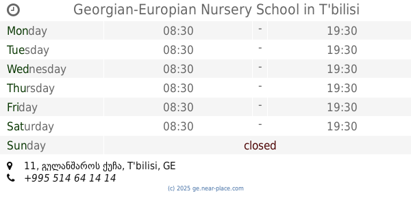
Georgian-Europian Nursery School
11 გულანშაროს ქუჩა, Tbilisi
School
read more
1.844 km
Saint Nicholas School
21, 0154 ლუბლიანას ქუჩა, Tbilisi
School
read more
2.364 km
Kai Khma
Tbilisi
School
read more
2.458 km
Never Land
8 ლუბლიანას ქუჩა, Tbilisi
School
read more
2.806 km
Общественный Коллеж Хареба Улица Любляна N5
5 Giuli Chokhonelidze Dead End, Tbilisi
School
read more
2.883 km
kings
8 Akaki Beliashvili Street, Tbilisi
School
read more
3.504 km
140 საჯარო სკოლა
5 Mose Gogiberidze Street, Tbilisi
School
read more
3.647 km
სკოლა N130
Tbilisi
School
read more
3.82 km
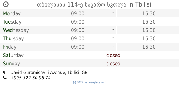
თბილისის 114-ე საჯარო სკოლა
David Guramishvili Avenue, Tbilisi
School
read more
3.982 km
143 სკოლა
9 შატილის ქუჩა, Tbilisi
School
read more
4.091 km
138 public school
Tbilisi
School
read more
4.15 km
15th secondary school
Tbilisi
School
read more
4.179 km
Public School #15
3 Gudamakari Street, Tbilisi
School
read more
4.408 km
207 Public School
Chargali Street, Tbilisi
School
read more
4.515 km
Public School № 167
Tbilisi
School
read more
4.819 km
სკოლა ალმასი
Tbilisi
School
read more
📑
all categories
Accounting
Administrative area level 1
Airport
Amusement park
Aquarium
Art gallery
Atm
Bakery
Bank
Bar
Beauty salon
Bicycle store
Book store
Bowling alley
Bus station
Cafe
Campground
Car dealer
Car rental
Car repair
Car wash
Casino
Cemetery
Church
City hall
Clothing store
Colloquial area
Convenience store
Courthouse
Dentist
Department store
Doctor
Electrician
Electronics store
Embassy
Establishment
Finance
Fire station
Florist
Food
Funeral home
Furniture store
Gas station
General contractor
Grocery or supermarket
Gym
Hair care
Hardware store
Health
Home goods store
Hospital
Insurance agency
Jewelry store
Laundry
Lawyer
Library
Liquor store
Local government office
Locality
Locksmith
Lodging
Meal delivery
Meal takeaway
Mosque
Movie theater
Moving company
Museum
Natural feature
Neighborhood
Night club
Park
Parking
Pet store
Pharmacy
Place of worship
Plumber
Point of interest
Police
Political
Post office
Premise
Real estate agency
Restaurant
Roofing contractor
Route
School
Shoe store
Shopping mall
Spa
Stadium
Storage
Store
Subway station
Supermarket
Synagogue
Train station
Transit station
Travel agency
University
Veterinary care
Zoo
sublocality level 1
↑